

Receiving “radar vectors” is common both in VFR and IFR scenarios. It might sound like a complicated term, but it’s really simple once you understand what it is and what it means. So what are radar vectors?
Radar Vectors are a navigational aid used by Air Traffic Control to route aircraft for traffic spacing, weather avoidance, and navigation assistance that typically come in the form of a specific magnetic heading assignment, or a left or right turn in number of magnetic compass degrees.
When I think of radar vectors I picture an imaginary line connecting my aircraft to a point where ATC is directing me. In this article we will have an in depth look at what exactly are radar vectors, why they are used and how they are a useful air traffic control technique to sequence aircraft.
What are Radar Vectors?
Radar Vectors are a navigational assist or aid used by Air Traffic Control (ATC) to get you to a specific spot. Radar Vectors may be requested by the pilot or may be given by the controller as an instruction to the pilot.
One important aspect to consider is that in order to receive a vector an aircraft must be visible by an air traffic controller on a radar screen.
Radar vectors are typically associated with IFR flight however, a VFR pilot may request vectors towards a specific point if under flight following.
In essence, a radar vector is an instruction by ATC that gets you to a certain point via a specified instruction, typically via a heading but you may be surprised to learn there are other ways to get “vectored”.
Vectoring Methods
FAA Order JO 7110.65Z – Air Traffic Control prescribes air traffic control procedures and phraseology for use by personnel providing air traffic control services.
Section 6 of this order covers vectoring and Section 5-6-2 covers the available methods for vectoring. A controller may vector aircraft by specifying:
- Direction of turn, if appropriate, and magnetic heading to be flown
- Example: “Turn Right Heading 180.”
- Interestingly “Fly present heading” is another example of this type of a vector request even though it may not sound like it.
- The number of degrees, in group form, to turn and the direction of turn
- Example: “Turn 40 degrees left.”
- For No-Gyro procedures, the type of vector, direction of turn and when to stop turn.
- Example: “This will be a no-gyro vector. Turn Right. Stop turn.”
The first two vectoring specifications are pretty self-explanatory. However, no-gyro procedures present a bit of a more interesting case. A no-gyro vector can be provided in case of a malfunctioning gyro-compass or directional gyro.
Gyroscopic instruments include attitude indicators, heading indicators, and turn coordinators. Modern avionics have taken out mechanical gyroscopes out of their design however, the name no-gyro is still used for this type of vectoring/approach used when there is a heading instrument malfunction.
No-Gyro requests can be uncommon and the Instrument Practical Test Standard (PTS) does not require a no-gyro approach however, various pilot and ATC blogs I read stated that they had used this type of approach especially for flight training.
Reasons for Using Radar Vectors
There are many reasons you might receive radar vectors while flying either VFR or IFR, but it doesn’t have to be confusing once you understand why you might receive them! Here are some examples.
Vectors for Traffic Pattern Entry
Vectors are commonly used to put aircraft into the pattern for an airport. In VFR conditions a controller might vector you into a known position in the traffic pattern before being handed off to the Tower Frequency.
For example, I was recently flying over the West Side of Wichita on a VFR afternoon and upon announcing my intentions of returning to the airport I was given various heading assignments for traffic sequencing that ended up putting me in a position to enter a right base into RWY 19L at ICT before being handed off to Tower to complete the flight.
For a real example of how this would look, below is a video on our YouTube channel showing procedures for flying into a Class D airport (Addison) underneath very busy Class B airspace in Dallas, Texas.
Radar vectors (via heading assignments) were given many different times from various approach controllers, before ultimately being cleared to land at the destination airport.
The whole video has great tips on how to navigate Class B airspace but if you are mostly interested in the vectoring portion of this flight you can forward to around 9:20 to see that example.
Vectors for an Instrument Approach
If weather is below VFR conditions then the aircraft will be vectored towards an instrument approach for the airport before being handed off to Tower.
Typically you would hear a command sounding something like “N123 fly heading 1-6-0, vectors for the ILS”.
This sets up the pilot to expect the instrument landing system (ILS) localizer to appear on the aircraft instruments.
After that, the controller will usually tell the pilot to make another turn to join the localizer, and will also be cleared for the approach.
Vectors for Traffic Avoidance
ATC may provide a vector if in the controller’s judgment the vector is necessary for air safety.
I recall a particular flight when I was flying on a constant heading while on VFR Flight Following. ATC was reporting traffic at my 12 o’clock which I was unable to either visually make or identify on my screen.
They updated me at least two more times before requesting an immediate turn a certain number of degrees to avoid the traffic.
I was glad to be under radar surveillance at the time as I was never able to visually make the traffic but thanks to some vectoring by ATC I was able to continue safely on my flight.
Vectors for VFR or IFR Departure Instructions
If you receive VFR Flight Following when talking to clearance delivery or ground control, they might include a heading assignment as part of your departure instructions.
A common one when departing Addison (KADS) is to fly runway heading and maintain VFR at or below 2,000 feet. The runway heading assignment is a vector you are receiving preemptively.
ATC might also provide vectors as part of your IFR clearance departure instructions.
The following is an example of an IFR clearance that includes radar vectors for an aircraft departing from Palo Alto (KPAO) to Stockton (KSCK):
“Cessna 21756, cleared to Stockton Airport via turn right heading zero-six-zero within one mile of the airport. Radar vectors San Jose, then as filed. Maintain three thousand expect five thousand five minutes after departure. Departure frequency is one two one decimal three. Squawk four two six three.”
The “Radar vectors San Jose” part of this clearance tells the pilot to expect radar vectors from ATC on the way to the San Jose VOR.
If you are more of a visual learner, here is a short video from our channel covering how IFR clearances are given, and in this example it includes radar vector instructions during the departure.
Diverse Vector Areas (DVA)
A newer area of discussion on radar vectors is Diverse Vector Areas (DVA), first published in 2014 and now published as part of “Takeoff Minimums, (Obstacle) Departure Procedures, and Diverse Vector Areas (Radar Vectors).
Diverse vector areas are utilized by ATC radar facilities to allow the radar vectoring of traffic below the minimum vectoring altitude (MVA), or for en route facilities the minimum IFR altitude (MIA) (FAA order 8260.3E).
DVAs are established for the most part at larger airports as a means to guarantee obstacle clearance for aircraft departing on radar vectors.
You can see below how DVA information would be published for a busy area like Santa Monica, CA. In this example we are looking at Santa Monica Municipal Airport (KSMO) which is inside the KLAX Class B airspace.
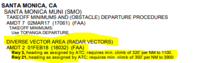
As can be seen in this example in some instances, the DVA information will be accompanied by minimum climb performance information.
Radar Vector Requirements
To complete the discussion on Radar Vectors we should explore the “Radar” portion of this term.
The term “radar” refers to ATC’s ability for you to be visible on the controller’s radar screen and has less to do with any “radar” system or capability equipped in your aircraft.
If ATC can see you they can vector you for any of the reasons discussed above. However, there are additional requirements that must be met before ATC can vector you in to intercept the final approach course of an instrument approach.
You can read more through section 5-9-1 of FAA Order JO 7110.65Z.
From a pilot’s perspective there is nothing you need to do in this case but it’s interesting to read through this order and glance through the factors involved into deciding when you are to be vectored for the final approach course.
Credit to our ATC folks for having to think about all of these things so that we can focus on landing safely!
Getting Vectored During VFR Flight
As a VFR pilot you have the ability to use ATC services under VFR Flight Following. VFR Flight Following is not a required service from ATC but for the most part the likelihood of getting rejected is very low.
In most instances navigation and altitude will be at your discretion under VFR flight following but every once in a while you may be given heading assignment (vectors) due to other traffic, weather, or any of the reasons we have discussed in this article.
If getting vectored as a VFR flight, remember that you are expected to comply with ATC instructions unless you are unable to do so for weather or safety reasons.
If unable to comply with ATC’s request for vectors you may state “unable” and it would be good courtesy to state your reasoning.
Remember that ATC may not be aware of the weather conditions in your position, it is good practice to provide any weather updates that may be pertinent to your flight so that ATC is able to give you more favorable instructions.
Risks Associated With Vectoring
While receiving radar vectors might sound fairly easy (since you’re just being told where to go), that doesn’t mean you can pay less attention to what’s happening in the flight.
There are some inherent risks when being vectored that are good to be aware of:
Forgetting You Are Being Vectored
This can be especially the case when transferring between different controllers. A good practice is to report current heading and altitude when reporting with a new controller.
An example of how this may sound like could be: “Approach N916DF checking in 5,500 and 0-9-0 assigned on the heading.”
Misunderstanding the Vector
Sometimes it is possible for the flight crew to confuse instructions like “Turn left 10 degrees” and “Turn left heading 0-1-0 degrees”.
If you’re confused, always ask for clarification (even if it’s several minutes later!).
VFR Vectors into IMC
As discussed in the section regarding Vectoring during VFR flight, caution should be exercised when vectoring VFR flights so that the aircraft does not inadvertently enter IMC (instrument meteorological conditions, i.e. IFR) or come in proximity with terrain.
If you believe you are being put in a heading that would take you into IMC or close to terrain don’t wait to inform that fact to ATC.
A simple request like “unable” or asking for 30 degrees left or right of course to deviate around weather are fairly common pilot requests and could be the difference between an uneventful flight and one that you may remember for all the wrong reasons.
Final Thoughts on Radar Vectors
Radar vectors are a useful tool for air traffic management. They help manage air traffic by sequencing aircraft into busier airports, and provide additional safety precautions by helping avoid other traffic or areas of potential inclement weather.
Good communication between pilot and controllers is key for radar vector instructions to be effective. If a vector instruction puts you in a less safe situation than before or if there is any potential for misunderstanding you should always seek for clarity from your controller or request a different instruction if able.


