
Weather can be a topic that new and seasoned pilots alike spend too little time studying and as a result have to do the bulk of their learning in the cockpit in real-world scenarios. Avoiding storms and obviously hazardous weather is usually pretty easy for even the new pilot, but what about weather that appears safe but might be hiding more dangerous features than what meets the eye? Cumulonimbus clouds are a good example of this. Since they don’t look always look dangerous on the outside, a common question is why are cumulonimbus clouds dangerous?
Cumulonimbus clouds are associated with strong to even severe weather ranging from heavy rain to strong updrafts and downdrafts to tornados. Hazardous conditions exist in and around cumulonimbus clouds that can easily surpass the design criteria and performance capabilities of aircraft of all types.
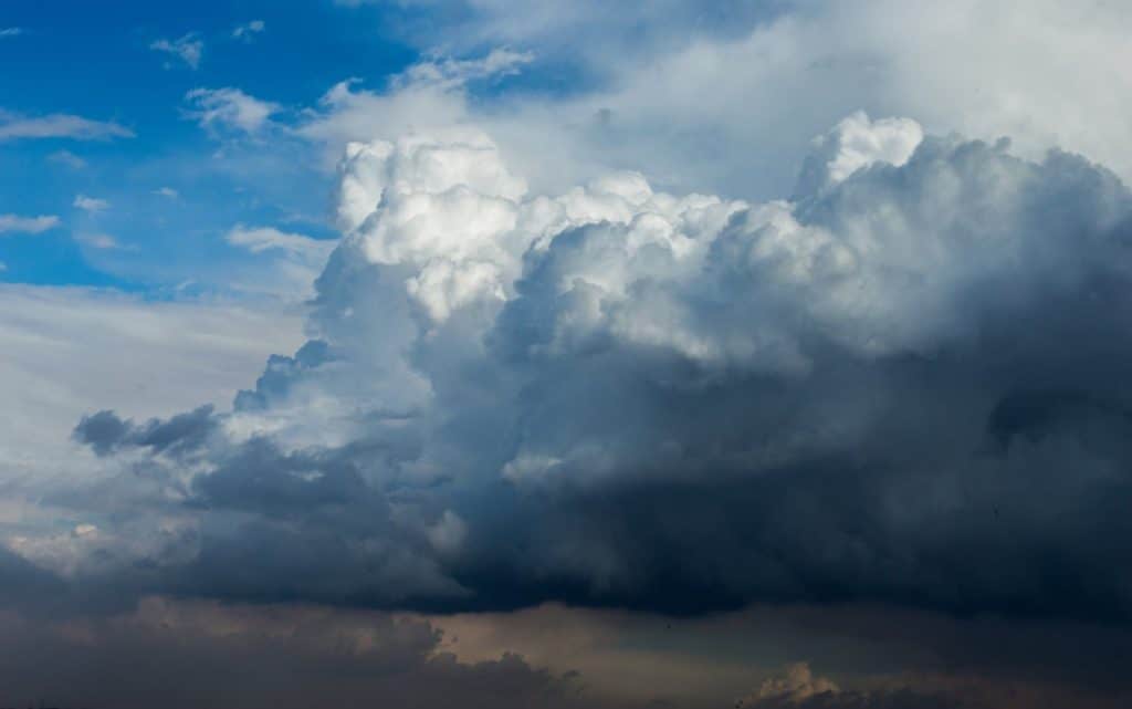
The defining characteristics of a cumulonimbus cloud, a towering column-like structure and falling precipitation, are indicators that hazardous conditions exist in and around the cloud. These clouds are most often associated with convective thunderstorm activity and occur in isolation, as part of squall lines, or as imbedded thunderstorms.
There are more hazards to cumulonimbus clouds than what meets the eye. Let’s cover each of these and discuss some tactics to safely navigating cumulonimbus cloud buildup.
Why are cumulonimbus clouds dangerous?
Here are some of the hazards that exist within cumulonimbus clouds and why they can be dangerous:
Rain
The most visually obvious hazard associated with cumulonimbus clouds is heavy rain. By definition this rain falls from the cloud base and may become extreme. Severe thunderstorms along squall lines may produce rainfall rates of greater than 2 inches of rain per hour. Extreme precipitation rates like this may be sufficient to flood pitot-static systems, overwhelm piston engine induction systems and flameout turbine engines.
Updrafts, Downdrafts and Extreme Winds
The large vertical development of a cumulonimbus cloud is the tell-tale sign of strong updrafts pulling moisture upward. Meanwhile, the presence of rain indicates that strong downdrafts have developed within the cloud; as these updrafts and downdrafts mix they produce extreme turbulence that may occur suddenly, posing the risk of structural damage to aircraft operating above their maneuver speed or turbulence penetration speed.
These updrafts and downdrafts and their associated turbulence may result in difficulty in maintaining altitude, airspeed, and attitude control of the aircraft. Even for aircraft passing below the cloud, these vertical wind currents pose a significant hazard.
The most famous examples of these extreme winds are known as microbursts; microbursts have been shown to create downdrafts in excess of 2,000 feet per minute and surface winds in excess of 100 knots. Additionally, downdrafts will often result in a leading gust front ahead of the cloud.
Gust fronts result in sudden changes in wind strength and direction; in certain conditions a gust front may even be visible on weather radar as it kicks up dust and debris as it pushes ahead of the cumulonimbus cloud. The strong updrafts associated with cumulonimbus clouds may be sufficient to lift light aircraft upward to altitudes where icing and hypoxia become threats to the pilot and the aircraft.
Icing Conditions
As moisture is lifted into the cloud, it will reach the freezing level and will pose an icing threat to aircraft, even aircraft certified for flight into known icing conditions. Flight into known icing (FIKI) requirements for even large turbojet aircraft do not address the threat of Supercooled Large Droplets (SLD) often present within cumulonimbus clouds. This type of icing is associated with liquid water that is cooled below 0°C but has not yet formed an ice crystal.
When an aircraft passes through a region of SLD, extreme ice build-ups result across the aircraft potentially blocking air data sensors, causing engine flameouts, and creating significant aircraft control issues. Even in cumulonimbus clouds without SLD icing present, the high moisture content, combined with temperatures near or below freezing, is sufficient to cause rapid ice buildup.
Often, the tops of these clouds represent the greatest threat and potential for icing, even brief encounters may result in large ice build ups; therefore, non-FIKI capable aircraft should always avoid these conditions and FIKI capable aircraft should exercise extreme caution.
Hail
Where there are strong updrafts and freezing temperatures, there is the possibility of hail. Hail is destructive in any size or concentration for aircraft of any size. Hail forms as a result of ice pellets repeatedly being lofted high into a cumulonimbus cloud, then falling and being lofted once again; the stronger the updrafts present in the cloud, the larger hail will grow prior to falling to the surface.
Notably, hail may even be ejected from the tops or sides of a cumulonimbus up to significant distances from the cloud itself.
Additionally, hail is not depicted on weather radars. Hail prediction is often accomplished using Doppler radar to observe the strength of updrafts and downdrafts within the cloud. Because weather radars do not observe frozen precipitation, hail is not directly observable, making it an all but invisible hazard to flight crews.
Hail will damage or destroy engines, propellers, windshields, air data probes, communication and navigation radio antenna, lights and may even cause significant structural damage beyond the inevitable “golfball treatment” the aircraft is bound to receive during a hail encounter.
Lightning
Another cumulonimbus hazard associated with strong turbulence, updrafts and downdrafts is lightning. The mixing air, dust, and water molecules results in the build-up of electrical fields within the cloud itself, which is ultimately discharged in often spectacular form. Lighting is often a good visual clue of both the strength of the updrafts and the downdrafts within a cumulonimbus cloud.
While lighting does not pose a direct hazard to pilots or passengers within an aircraft, the side effects of a lightning strike on crew members and aircraft systems are significant. Crew members may suffer visual impairment and disorientation immediately following a lightning strike, these hazards are of particular concern at night while in IMC, as the crew will likely suffer a loss of night vision and subsequently risk difficulty maintaining a sufficient instrument scan.
The aircraft may also suffer damage to electrical equipment, including damage to communication and navigation radios, avionics equipment, or to other aircraft systems. The build-up of static charge on the aircraft in a lightning prone environment may also block radio communications with other aircraft and Air Traffic Control.
Tornadoes
The “grand daddy” cumulonimbus cloud hazard is the tornado. Tornadoes are most often associated with severe squall line thunderstorms, particularly in the Midwest and Southern United States. While Tornadoes rarely reach above 1 mile in diameter, they indicate extreme turbulence, hail, high surface winds, lightning, and precipitation are all present within the cumulonimbus cloud.
Cumulonimbus clouds capable of producing a tornado often reach altitudes above 50,000 feet, making circumnavigation the only reasonable method to avoid cumulonimbus clouds actively producing a tornado.
How Do Pilots Minimize The Cumulonimbus Cloud Hazards?
The simplest answer to minimizing exposure to the dangers of cumulonimbus clouds is to avoid them all together. When airborne, if a flight crew identifies an area of cumulonimbus development; selection of an alternate route is best initial plan of action. In general it is best to remain on the upwind side of a cumulonimbus cloud, and to remain clear of it by at least 20 nautical miles.
For storms with large anvil or shelf formations, avoid flying under these areas, as hail, lightning, and severe turbulence may all exist in these areas. VFR pilots must not be tempted to skirt under the bases of cumulonimbus clouds as the potential for a sudden decrease in visibility due to heavy rain, significant turbulence, updrafts, downdrafts, and lightning all exist, even when in clear air.
Prior to flight, use good weather planning techniques; review convective SIGMETS along the route of flight, review prog charts and surface analysis charts, and of course use radar and satellite imagery to identify areas of existing cumulonimbus cloud formations.
In flight weather resources are also valuable for circumnavigating areas of cumulonimbus cloud formation. HiWAS, ATC, onboard weather radars, Stormscope systems are all excellent resources for predicting, identifying, and avoiding areas of cumulonimbus development.
Where Are Cumulonimbus Clouds Likely To Form?
During preflight planning, it is important to consider where cumulonimbus clouds may form. Because cumulonimbus clouds feed on atmospheric instability, expect to see them where unstable conditions prevail. High humidity, high temperature lapse rates, warm temperatures, and atmospheric or geographic lifting actions will all tend to trigger cumulonimbus cloud development.
Cumulonimbus development may occur as distinct, isolated showers and storms, or may develop, under the right conditions, into a line of powerful severe storms. Isolated cumulonimbus clouds are likely to occur as a result of convective heating and sufficient atmospheric moisture. Summer-time storms in Florida are an excellent example of these types of cumulonimbus clouds.
Alternately the lines of severe weather crossing hundreds of miles in the Midwest each spring are the result of the interactions of strong cold fronts and warm, moist air. This interaction typically triggers the development of cumulonimbus clouds and their most extreme hazards along a “dry line.”
Larger storm systems that form along the boundaries of low pressure systems likely include embedded cumulonimbus clouds that are all but invisible to pilots. These systems result in complex storm dynamics that present a wide mix of hazards; it is best to avoid these areas as the pilot’s greatest tool for identification of cumulonimbus cloud formations will be obscured by instrument meteorological conditions.
Dealing With Cumulonimbus Clouds
Pilots should consider cumulonimbus clouds as being synonymous with thunderstorms. The primary goal should be avoidance of these areas and the associated hazards, as any of the hazards associated with cumulonimbus cloud development may overwhelm the ability of a flight crew or aircraft to successfully transit a cumulonimbus cloud. A cumulonimbus cloud that seems to be “not that bad” may very quickly become significantly dangerous.
It is important to remember that if a flight crew does find themselves in a cumulonimbus cloud facing the numerous hazards present, prioritize according to aviate, navigate, communicate. The first priority for flight crews encountering a cumulonimbus formation is to simply keep the airplane upright and under control; slow to maneuvering speed and focus on maintaining a level attitude rather than an altitude or even airspeed.
Use onboard weather tools, to the extent that they are available, to navigate out of the storm, but do not turn around to avoid additional stress on the airframe; small and gradual heading changes should be used. Use anti-ice equipment as an icing encounter is likely. Use ATC resources to communicate the need for assistance exiting the cloud and associated weather conditions.
While cumulonimbus clouds are dangerous, harboring heavy rains, extreme turbulence and wind, icing conditions, hail, lightning, and even tornadoes, the clouds themselves are easily identified by their towering shape and associated rainfall. By avoiding flight through these clouds, and by remaining well clear of them, pilots may safely enjoy their magnificence and beauty.


