
How well do you know the inner workings of your altimeter? Most of us understand that it uses pressure differentials to calculate altitude above sea level, and it is common place to receive barometric pressure settings to calibrate your altimeter based on the conditions of that area at that time. But is there anything else that might be impacting your altimeter? What about temperature? How does temperature affect altimeter readings?
In conditions that are colder than standard temperature, the altimeter will overstate your altitude. The higher your altitude, the more it will be overstated. In conditions that are warmer than standard temperature, the altimeter will understate your altitude.
Honestly this concept never really stuck with me during flight training, but is starting to make more conceptual sense and seem more applicable now that I am dipping my toe in mountain flying. Understanding what might impact your altimeter (aside from just barometric pressure) will make you a safer pilot.
I tend to learn things best when I can understand the “why” behind a concept, and also understand a practical situation in which it will be applied. So, I wanted to share my research behind why the altimeter is impacted by temperature, the degree to which it’s impacted, and practical application for these situations. So, let’s dive in!
Why does temperature affect altimeter readings?
It’s important to understand from the start that altimeters aren’t actually measuring altitude at all. Rather, they measure pressure, and convert this information into an altimeter reading in relation to mean sea level, or MSL.
Our altimeters are calibrated to work accurately at standard pressure (29.92 inches of mercury) and standard temperature (15 degrees Celsius, or about 59 degrees Fahrenheit). Because atmospheric pressure changes from hour to hour, and region to region, it is seldom a “standard” atmosphere (read our article on “Why is 29.92 the standard altimeter setting?”).
To correct for non-standard pressure, modern altimeters can reset the actual barometric pressure into the Kollsman window of the altimeter for more accurate readings.
What isn’t depicted on the altimeter, but still affects it nonetheless, is temperature. Temperature has a significant effect on air pressure, which in turn impacts the altimeter.
Warmer air has lower pressure, whereas cooler air has higher pressure. This can seem a little backwards since hot air expands and can seem to increase in “pressure” as it relates to the surface around it (for example your car tire expanding in the summer and appearing flat in the winter without any change of air volume to the tire).
However, think of air pressure in the context of an altimeter as the weight of the atmosphere pushing down on the earth.
The first several minutes of this video explains this concept quite well:
How much does temperature affect altimeter readings?
As mentioned earlier, we can easily calibrate the altimeter for non-standard pressure settings, but we don’t have a similar mechanical calibration for non-standard temperature settings. There is a somewhat simple calculation to roughly estimate the variance, and it is 4 feet per degree Celsius of difference from standard temperature for every 1,000 feet above the reporting altitude.
In other words, you need two inputs:
- Difference between actual air temperature and standard temperature
- Altitude above the reporting location (for example, your destination airport)
For example, if the airport you are landing at is reporting air temperature of 5 degrees Celsius, and you are flying at pattern altitude of 1,000 feet, the calculation would be:
4 feet * (5 degree reported temp – 15 degree standard temp) * 1 (thousand) = -40 feet vs. what the altimeter reads
Conversely, on a very hot Texas day of 40 degrees Celsius the calculation would be:
4 feet * (40 degree reported temp – 15 degree standard temp) * 1 (thousand) = +100 feet vs. what the altimeter reads
Here’s a high-level visualization of this phenomenon:
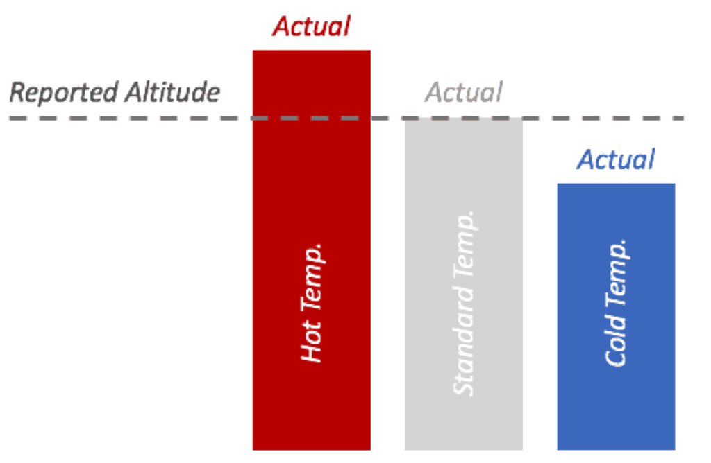
Keep in mind that from the graph above, this principle is magnified the higher you are above the reporting location. You might already see that the variance isn’t as troublesome in high temperature situations where you are actually higher than what your altimeter is showing. It is in cold weather operations that this altimeter variance becomes an issue much more quickly, particularly when it comes to obstacle clearance and IFR operations.
Memory Techniques
A common phrase to remember the relationship of temperature and altimeter readings is “high to low, look out below.” Meaning if you are going from high temperature to low temperature, “look out below” because you will be closer to the ground than you think based on your altimeter reading.
Another option is to remember that in higher temperatures, you are higher than the altimeter reads. In lower temperatures, you are lower than the altimeter reads.
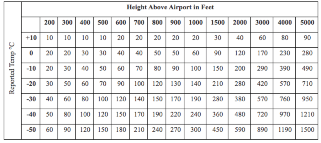
Luckily, to save some of the mental math from the equation above, the FAA published common calculations in Table 7-2-3 of the Aeronautical Information Manual (AIM). You’ll notice they primarily focus on cold weather scenarios, as that’s where the dangers can more typically arise.
From the example above, a -40 or even +100 foot difference doesn’t really seem to make a huge difference to your flight at pattern altitude, particularly in a VFR scenario. But what about when you are 5000 feet above the airport elevation on a very cold day flying an approach in IMC in the mountains where obstacle clearance has been built into the approach fixes and descent gradients, and altimetry variances start to matter quite a bit. This is where the practical application comes into play.
Practical Application
The FAA publishes a list of Cold Temperature Restricted Airports (CTRA) where there is a risk of flight safety (notably obstacle clearance) during cold weather operations. This list, and applicable procedures related to it, are updated approximately monthly and will be available on this website (link to FAA Notices to Airmen).
In order to come up with this list, the FAA basically looked at airports with runway lengths of 2,500 feet or greater (due to “database constraints”) and looked at the coldest recorded temperature at each of those airports within the last five years. They then calculated the estimated barometric altimetry errors that would result from those temperatures (using the table above) to see if such error would exceed the Required Obstacle Clearance (ROC) for approaches into those airports. If the probability of the ROC being exceeded went above one percent on any segment of the approach, the airport was added to the CTRA list. (This is covered in the “Background” section of the Notices to Airmen available at the link above.)
For airports with runways less than 2,500, the FAA basically says you are on your own to figure out if altitude corrections need to be made in cold temperature operations.
Luckily, you don’t need to memorize the airports on this list, as the FAA also added a snowflake symbol to the approach plates of any airport on this list. Eagle County Regional Airport (KEGE) is an example:
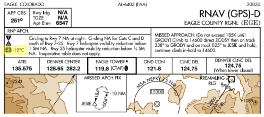
You’ll also notice that it has a temperature next to the snowflake symbol. This indicates the temperature at which point the altimeter corrections need to be made. In the case of KEGE, these procedures apply when the reported airport temperature is at or below -18 degrees Celsius.
At a high level, if your destination airport includes that symbol, you would then consult the latest Notices to Airmen document and see to which portions of the approach these altitude corrections apply. Some might apply only be the final approach fix, the holding fix, or it might apply to all segments of the approach.
Using KEGE as an example, as of the February 2020 Notices to Airmen, altitude adjustments applied to just the intermediate segment of the approach.
You then need to do some math using the cold temperature error table (above), determining your altitude correction based on the applicable segment’s height above the airport in feet as well as the reported temperature.
DISCLAIMER: This post is meant to be a general overview as to how to apply these procedures, NOT as an overall substitute for reading the FAA’s guidance on these procedures.
The latest Notices to Airmen publication will require detailed instructions on how to apply the altitude corrections and is worth reading in its entirety (it’s only a few pages) to ensure you are applying it correctly. You can find the latest Notices to Airmen here and then search within the document for “Cold Temperature Restricted Airports.” It will include the latest information as to how to use the document. When it comes to obstacle clearance, thoroughness in your preparation for the flight is paramount.
It’s worth noting that newer avionics will sometimes have an option to make these altitude corrections for you. Be sure to familiarize yourself with the capabilities of your avionics suite when it comes to CTRA (Cold Temperature Restricted Airport) operations. At the end of the day, YOU as pilot in command are in charge for the planning, execution, and overall safety of the flight.
Reporting Requirements
The FAA guides that pilots should advise ATC they are utilizing altitude corrections for any approach segment except the final segment. Practically speaking, they need to understand what altitude you’ll actually be flying at as it applies to their separation requirements with other traffic.
It is also worth noting that you should not change the altimeter setting in order to fly the corrected altitudes. Keep the altimeter setting you would normally use (as guided by ATC or the destination airport, as applicable) and then apply the altitude changes. In other words, don’t make an altimeter change to accomplish the altitude correction.
Real World Examples
AOPA put together a really nice presentation on this topic that walks through a couple different examples of cold temperature restricted airports. As much as I don’t want you to leave our site, I think this is really well thought out resource and I want to share it: AOPA Cold Temperature Restrictions Presentation.
Conclusion
While altimeters measure pressure to report altitude, and we can apply calibrations for non-standard pressure, temperature also plays a sometimes significant role of the reporting integrity of the altimeter. In particular, cold weather operations present the most immediate hazard to altimetry reporting errors as it will overstate altitude.
This can pose a risk to appropriate obstacle clearance and pilots should be familiar with the FAA’s list of Cold Temperature Restricted Airports, how to identify whether their destination airport is on this list, and the steps related to implementing altitude amendments for applicable segments of the approach.


